| The
Begwyns
An overall look at this large area of common land and its place in local archaeology - Article and photographs by B Bowker |
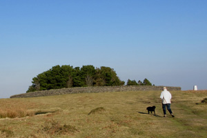
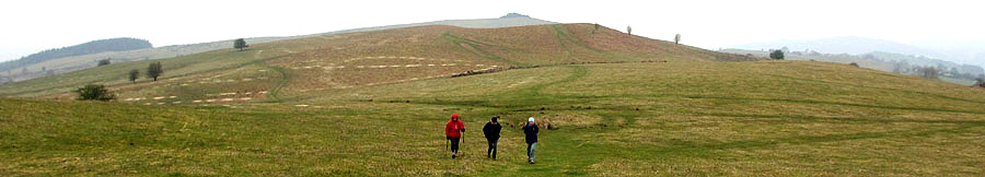 Heading East across the Begwyns with the Roundabout at the top of the picture - 20.04.2014 |
| Introduction The
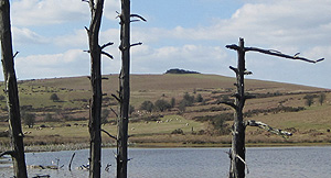
Begwyns is a large upland area and encompasses a wild and rolling
landscape of common land situated north of Ffynnon-Gynydd and south
of Painscastle. It rises to 415 m at the Begwyns Round Barrow (
contained in the summit Roundabout ) and falls away to a low point
of some 270 m to the NW. The whole area of 1292.98 acres had been
owned for a long period by the Maesllwch Estate before being gifted
to the National Trust by Major G. W. F. De Winton on the 7th July
1992. Since this time the National Trust has been overseeing and
surveying the area on a continuing basis. Alongside this both the
farmers and the National Trust have been and are developing a working
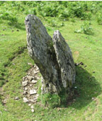
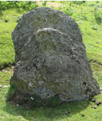
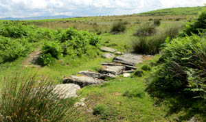
relationship regarding the management and preservation of the Begwyns The farms surrounding the Begwyns have possessed varying common rights since medieval times depending on their deeds. These are in the main pasturage, estovers and common in the soil and the farmers themselves have mutually exercised and managed these rights over the ensuing period. At a practicing level the rights refer to the grazing of sheep, ponies and cattle, along with the cutting and gathering of bracken for winter bedding on the surrounding farms. There has also been selective quarrying of rock and the shales over a long period, some of this being used for building purposes and some to improve the various trackways where necessary. It is worth noting that both the farmers and the National Trust have been and are developing a working relationship regarding the management and preservation of the area. Archaeology There is abundant physical evidence that the Begwyns have been occupied by man during prehistoric times and some indications for the medieval period, although at present nothing has been discovered to suggest an occupation by the Romans. There is also post medieval evidence of agricultural and wartime activities, latterday quarrying and the creation / improvement of access tracks and footpaths. Prehistoric Settlement Within the Roundabout lies the Begwyns Round Cairn, probably of the Bronze Age and a burial mounds of some 11m in diameter which has been much abused over the years by grazing animals, human traffic and tree planting. It is now a Scheduled Ancient Monument (S.A.M.) with a protected area of 22m in diameter. Other S.A.M.'s of note are as follows : - The Maesgwyn Round Barrow - GR 164 436 This is a grass covered barrow of some 19.5m in diameter and 1.6m high. The protected area is 26m in diameter The Bailey Bedw Ring Cairn - GR 165 442 This is a well constructed ring and possibly a burial cairn. It is 7m across and encircled by a stony bank up to 3m wide and 1m high. The protected area is a circle of 15m radius. The Begwyns Standing Stone - GR 153 450 ( Possible Prehistoric standing stone ) This is a large split stone of just over a metre high and a metre wide. It is nearly 0.5m thick and has a 8m diameter protected area. Along with 11 other lesser sites the four above are considered to be of the Bronze Age and all but one, the Maesgwyn Round Cairn, are located in the northern half of the Begwyns. The reason(s) for this are not fully understood and could be topographical, geological or to do with the climate at the time, which was decidedly more temperate. During the surveying of these sites a number of flint artefacts were found, these being four flint scrapers and three small fragments of flake debris. The size and knapping on the scrappers would suggest an early Bronze Age date Medieval Settlement This site is an extensive one with several earth
platforms. There are supporting stone foundations, of rectangular
long huts and a number of small attached enclosures. There is
also a series of larger enclosures defined by earth banks. Post Medieval to Contemporary The common rights ( mainly pasturage, estovers and common in
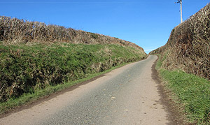
the soil ) have been in use since medieval times on the Begwyns
and during this period there have been improvements to existing
roads and trackways, a particular example being the road from
Ffynnon-Gynydd over to Painscastle, once a well worn ancient trackway
- as witnessed by the very high roadside hedges - and now a fully
metalled 'C' class road. B. Bowker Sources " Wales ", A
Physical, Historical and Regional Geography. Edited by E.
G. Bowen, M. A. F.S.A. Photographs - B. Bowker
|
|