|
Gwernyfed Settlement Clwyd Powys Archaeological Trust Historic Landscape Characterisation |
 |
|
The
Middle Wye: Gwernyfed Historic background |
|
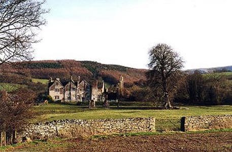
As yet there is no evidence of settlement in the area during the medieval pre-conquest period and it appears that unlike other lowland areas within the Middle Wye the area remained relatively remote from nucleated centres of population until perhaps the 18th and 19th centuries when both Felindre and Three Cocks emerged as roadside settlements on the turnpike roads between Talgarth and Hay. Following the Norman conquest the area fell within a sub-lordship of Glasbury, lying between the strategically more important sub-lordships of Hay and Talgarth. Gwernyfed is thought to have originated as a holding granted to Peter Gunter by Bernard de Neufmarché following the conquest of Brycheiniog, perhaps in an area that was still extensively wooded at that period. By the 14th century an English-held subtenancy had been established at Felindre to the east and a Welsh subtenancy had been established at Tyle-glas to the west. A manor house had been built at the site of Old Gwernyfed by the later medieval period, possibly to one side of a deer park covering an extensive tract of land stretching from the foothills of the Black Mountains near Felindre to the banks of the Llynfi at Aberllynfi. The deer park appears to have survived with relatively little alteration until the later 18th century and encompassed the area of Little Lodge and Tregoyd Mill to the north-east and Gwernyfed Farm and Tyle-glas to the south-west. The manor house at Old Gwernyfed was extensively rebuilt at the beginning of the 17th century. Probably also belonging to this period are the traces of a formal terraced garden laid out with earlier fishponds behind the house, of which the earthwork remains of a terrace and the stone pillars of a gated entrance survive. The principal residence of the owners transferred to Llangoed Hall near Llyswen in about the 1730s, though various ornamental elements were added to the deer park during the later 18th century and the early 19th century, including a series of radiating tree-lined avenues, a fountain and a maze. The formal gardens behind Old Gwernyfed appear to have become disused by the middle of the 18th century when the area of the gardens is shown as an orchard. The large Jacobean-style country house of Gwernyfed Park was built in the northern side of the park in the 1870s and 1880s, and said to be on the site of an earlier hunting lodge, together with walled kitchen gardens. This new house, with its long drive, lodge and massive wrought-iron gates was orientated upon the newer lines of communication to the north, passing through Three Cocks and Treble Hill, Old Gwernyfed with its attached farm buildings becoming the home farm. At this stage the park still extended to over 300 acres. Ornamental plantings of firs and beech were made throughout the park in the later 19th century, much of which still survives, though following the break-up of the estate in the 1950s most of the parkland was divided into arable fields by means of post and wire fences. The origin of the place name Gwernyfed has been the subject of much dispute, but suggestions have included the poetic 'sacred grove' and the more prosaic 'soaking bog'. Key historic landscape characteristicLow-lying, flat to gently sloping landscape, generally facing north-west and lying at a height of between 100-150m above Ordnance Datum. Present-day landscape is a combination of pasture, arable, garden and parkland, with some mixed deciduous and conifer plantations. Soils are predominantly well-drained fine loamy reddish soils (Milford Series) overlying sandstone bedrock. Present-day land-use is partly pasture with some arable and fodder crops. Settlement within the character area is largely confined to the two large and important houses at Old Gwernyfed and Gwernyfed Park and associated farms and farm buildings. Old Gwernyfed on the southern side of the area (now a hotel) is a large early 17th-century Jacobean manor house built in sandstone rubble, the south-west wing of which has been in ruins since a fire in about 1780, with a pair of circular Tudor dovecots with conical roofs in the original forecourt. The house forms part of a complex which includes largely 18th to 19th-century sandstone rubble farm buildings arranged around a courtyard, some with ventilation slits, some of the later buildings with brick dressings, and including a water-powered threshing barn fed by leat, installed in 1890s. Gwernyfed Park House on the northern side of the area (now a school) is a large country house in a neo-Jacobean style of the 1870s, built in sandstone ashlar, with stable block, lodge and gates, kitchen garden, and glasshouses. Tyle-glas, one of the few farmhouses in the area, is a complex of 18th-century rendered farmhouse and sandstone rubble outbuildings, partly converted Sources
Briggs 1991a; For further information please contact the Clwyd-Powys Archaeological Trust at this address, or link to the Countryside Council for Wales' web site at www.ccw.gov.uk. |