|
Aberllynfi Settlement to 1750
Clwyd Powys Archaeological Trust Historic Settlements Survey - Brecknock |
|
Aberllynfi
SO 172377 Introduction |
|
|
|
History of development There is evidence for both Iron Age and Roman settlement at
Aberllynfi (centred on the hillfort of Aberllynfi Gaer), though
neither is necessarily connected with the presumed area ofmedieval
settlement (examined here) nor the modern village at Three Cocks. |
|
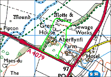
The Heritage to 1750
Aberllynfi Gaer, a scheduled ancient monument (494; SAM B159) is a small multivallateearthwork enclosure; typical of Iron Age hillforts in the region. Small-scale excavations in 1951 indicated that this site had had a long use, with evidence of Neolithic activity (which Clwyd Powys Archaeological Trust Historic Settlements Survey - Brecknock www.cpat.org.uk pre-dated the hillfort), and also Roman reuse of the site. Other signs of Roman activity have come from Gwernyfed Park to the south of the Gaer. Aberllynfi castle, also a scheduled ancient monument (513; SAM B80), is a typical medieval motte and bailey, though the bailey has been all but destroyed. Aberllynfi is generally assumed to be the castle that changed hands several times in 1233. The site of St Eigon's church (527) stands some 50m south-east of the castle and is now barely visible in an area of open low lying riverside pasture. The precise nature and plan of the building is not entirely clear, but it is a reasonable assumption that the stone-walled ruin (some 20m by 8m) standing on the traditional site is the church. If this is the case then the church was probably a simple, two-celled building, perhaps originally a chapel to the castle, and has subsequently assumed the role of a village church though there is no churchyard. Glasbury church register records marriages and baptisms at Aberllynfi up until 1695 and it appears to have gone out of use soon afterwards, though a date as late as 1731 has been proposed. There are antiquarian stories of monuments to the Williams’ family of Gwernyfed in the church. Possibly the area around the church and the castle contained some form of medieval settlement, although no obvious remains now survive. The most likely areas are probably to the south and west of the castle. Whether there was such settlement here, however, has yet to be determined. Great House Farm (9266) is a ruinous building, lying south of the castle, which probably dates from the 18th century and is of considerable local architectural interest. It is sited within semi-landscaped grounds (now comprising neglected orchard and woodland), and it is possible that any trace of medieval settlement in this area may have been removed by these features. The Three Cocks Hotel (20815) is stated to be a 16th or 17th-century coaching inn. Otherwise there are no buildings at Three Cocks obviously earlier than the 18th century, while the mill buildings (2988) and a barn (2989) adjacent to that building probably date from that century. These support the general contention that this part of Aberllynfi is merely the post-medieval re-location of the village. |