The Begwyns - Contemporary Archaeology
An overall look at this large area of common land and its place in contemporary archaeology


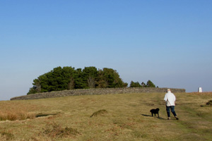
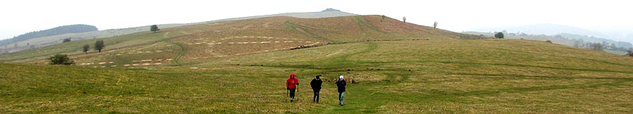
Heading East across the Begwyns with the Roundabout at the top of the picture - B Bowker - 20.04.2014
Introduction

The Begwyns is a large upland area and encompasses a wild and rolling landscape of common land situated north of Ffynnon-Gynydd and south of Painscastle. It rises to 415 m at the Begwyns Round Barrow ( contained in the summit Roundabout ) and falls away to a low point of some 270 m to the NW. The whole area of 1292.98 acres had been owned for a long period by the Maesllwch Estate before being gifted to the National Trust by Major G. W. F. De Winton on the 7th July 1992. Since this time the National Trust have been overseeing and surveying the area on a continuing basis.
The underlying rocks are silurian shales and mudstones to the north, merging to old red sandstones in the south and the area is complicated with some latterday glacial drifts due to the ice sheets overspilling from the main Wye Glacier. There are a few natural mawn pools which can dry up during the summer months and some small recently created pools which cater for the animals grazing the common. There is one large pond, the Monks Pond, which has been enlarged in recent times to provide a reliable year long water supply for the Perthiduon farm. The vegetation is mainly rough grassland and bracken, with a fair scattering of cotton grass, gorse and some resilient hawthorn trees. There are also some heather patches in the more peaty area by the two mawn pools to the west of the Roundabout.
It is worth noting that both the farmers and the National Trust have been and are developing a working relationship regarding the management and preservation of the area.

The Roundabout

The original Roundabout was built by the de Winton family in 1887 to protect the numerous trees which had been planted to commemorate Queen Victoria's Diamond jubilee. These gradually disappeared over time along with the wall which fell into total disrepair by the mid 20c.
The trees were replaced in 1977 by the Maesllwch estate and stock proofed by Rhosgoch Y.F.C. This was to commemorate the silver jubilee of Queen Elizabeth 11.
The surrounding wall was rebuilt as a funded Millennium project by the National Trust and the Painscastle Community and help was provided by volunteers who were learning a trade . The surrounding wall was built in just over 3 months and is standing the test of time.
Access is provided by two styles, roughly north and south, and the impressive circular seat was built in June 2000 under the direction of Mr Richard Harris of Rhosgoch.

The Triangulation Pillar

The triangulation point close by was adopted in January 1997 by the Beagley family of Cornhill and has been maintained by them admirably since that time.

Wartime Activity

Some temporary but important events occurred during World War Two when the War Agricultural Executive Committees implemented farming changes for a second time. The effect of the "War Ags" was to increase the productive land in the UK by over 1.5 million acres between 1939 and the early 1940's 
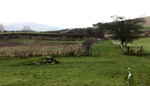
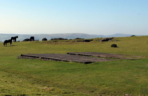
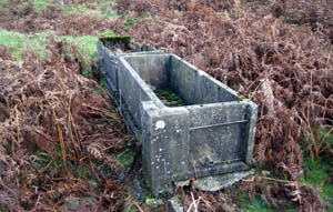
and this included large areas of the commons of Ffynnon-Gynydd
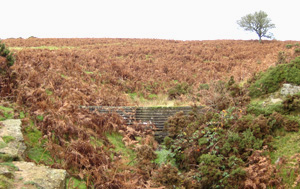
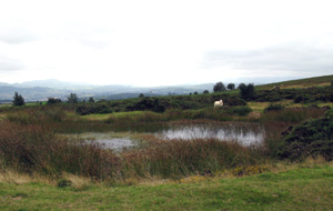
 and the Begwyns.
Milk, potatoes and cereals were considered to be essential to the food supply and a large part of the Begwyns was commissioned for the grazing of cattle and the growing of mainly potatoes. Some 300 acres were fenced off and ploughed, initially for growing oats and afterwards for potatoes. These were clamped and stored on the common to be used as and when required.
Two nissen style huts with concrete bases were built to house the necessary equipment and a loading ramp constructed at GR 139 435 to service transport of the produce from the Begwyns. The huts were also used as repair sheds and shelters for lunch breaks and foul weather conditions. Along with the farmers, land-girls were mainly employed along with a few POW's in the construction, planting and running of the scheme.
After the war and around 1949 the graziers held a meeting and decided that the land should revert to common usage but there are some remaining legacies worthy of note.

Approaching from the west the first of these can be found at GR 139 435 and is the loading ramp mentioned above.

The second can be found at GR 143 435. These are the two concrete bases; all that is left of the nissen style huts.

The third is the small dam and related water troughs which were constructed for the benefit of the cattle and can be found in the area of GR 149 436. The water was piped from the dam to the troughs to provide a reliable and safe supply.

The fourth was a post-war event and is known locally as 'The Bomb Hole' . During the war ammunition was safely stored in a variety of depots ( A large one was created at Gwernyfed ) and these became redundant with the advent of peace. After a few minor and trial explosions it was decided to dispense with the remaining ammunition in one fell swoop and the Begwyns was the favoured and chosen site. In due course the ammunition was sited at a safe distance from the road at GR 178 443 and the demolition team at a even safer distance in the ditch to the southwest. The bomb-blast was successful but ruptured the bed-rock below, allowing a spring-line to create a small lake which has remained since
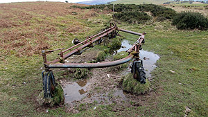
 that time
In the aftermath there was significant structural damage to some local farm buildings and this resulted in token monetary compensation where necessary.

The Bamford Hay Rake

This unusual relic was discovered in a little visited area on the Begwyns. It was identified by Paul Greenow as a Bamford Hay Rake and was probably abandoned in the early 1950's.
The apparent suspension is probably not due to geological erosion alone but more likely to be from a combination of weathering and sheep treading, as they rub off their woolen coats when the weather warms up. Traces of this can be seen in the photograph opposite.


B Bowker
October 23rd 2017

Sources

"Wales",  A Physical, Historical and Regional Geography.  Edited by E. G. Bowen, M. A.  F.S.A.
National Trust archival material and reports
Mr Paul Greenow
Mr Fred Lloyd
Mr A A Nicholls of Croesfeilliog
Mr Aubrey Price of Llwynpenderi
Other local farmers

Photos - B Bowker


Approaching the Roundabout Wall from the West
The Triangulation Pillar can be seen on the right
02/03/2013


The loading ramp and the track leading off the common
06.12.2014


The twin concrete bases at GR 143 435 - all that is left of the
"War Ags" Nissen style huts - 26.03.2012


The concrete dam at GR 149 436 which was piped
to the cattle troughs below - 22.11.2011


The remains of the cattle troughs below the dam
on the true right bank - 22.11.2011


The Bomb Hole at GR 178 443. A permanent pond
in an unlikely location - 14.09.2012


The Bamford Hay Rake - 03.03.2016